


WESTBORO - T 1 Voting District, Taylor County, Wisconsin
About
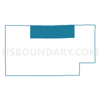
Outline

Summary
| Unique Area Identifier | 697192 |
| Name | WESTBORO - T 1 Voting District |
| County | Taylor County |
| State | Wisconsin |
| Area (square miles) | 125.42 |
| Land Area (square miles) | 124.10 |
| Water Area (square miles) | 1.32 |
| % of Land Area | 98.95 |
| % of Water Area | 1.05 |
| Latitude of the Internal Point | 45.33516060 |
| Longtitude of the Internal Point | -90.46440330 |
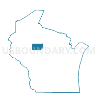
Maps

Graphs
Select a template below for downloading or customizing gragh for WESTBORO - T 1 Voting District, Taylor County, Wisconsin


Neighbors
Neighoring Voting District (by Name) Neighboring Voting District on the Map
- CHELSEA - T 1 Voting District, Taylor County, WI
- CLEVELAND - T 1 Voting District, Taylor County, WI
- GREENWOOD - T 1 Voting District, Taylor County, WI
- GROVER - T 1 Voting District, Taylor County, WI
- HAWKINS - T 1 Voting District, Rusk County, WI
- HILL - T 1 Voting District, Price County, WI
- JUMP RIVER - T 1 Voting District, Taylor County, WI
- KENNAN - T 1 Voting District, Price County, WI
- MOLITOR - T 1 Voting District, Taylor County, WI
- OGEMA - T 1 Voting District, Price County, WI
- OGEMA - T 2 Voting District, Price County, WI
- RIB LAKE - T 2 Voting District, Taylor County, WI
Top 10 Neighboring County Subdivision (by Population) Neighboring County Subdivision on the Map
- Rib Lake town, Taylor County, WI (852)
- Chelsea town, Taylor County, WI (806)
- Ogema town, Price County, WI (713)
- Westboro town, Taylor County, WI (684)
- Greenwood town, Taylor County, WI (638)
- Jump River town, Taylor County, WI (375)
- Kennan town, Price County, WI (356)
- Hill town, Price County, WI (333)
- Molitor town, Taylor County, WI (324)
- Cleveland town, Taylor County, WI (268)
Top 10 Neighboring Place (by Population) Neighboring Place on the Map
Top 10 Neighboring Unified School District (by Population) Neighboring Unified School District on the Map
- Medford Area School District, WI (14,380)
- Phillips School District, WI (6,041)
- Ladysmith-Hawkins School District, WI (6,020)
- Gilman School District, WI (3,213)
- Prentice School District, WI (2,966)
- Rib Lake School District, WI (2,673)
Top 10 Neighboring State Legislative District Lower Chamber (by Population) Neighboring State Legislative District Lower Chamber on the Map
Top 10 Neighboring State Legislative District Upper Chamber (by Population) Neighboring State Legislative District Upper Chamber on the Map
Top 10 Neighboring 111th Congressional District (by Population) Neighboring 111th Congressional District on the Map
Top 10 Neighboring Census Tract (by Population) Neighboring Census Tract on the Map
- Census Tract 9601, Taylor County, WI (4,290)
- Census Tract 9601, Rusk County, WI (3,792)
- Census Tract 9707, Price County, WI (2,514)
- Census Tract 9602, Taylor County, WI (2,331)
- Census Tract 9706, Price County, WI (2,268)
Top 10 Neighboring 5-Digit ZIP Code Tabulation Area (by Population) Neighboring 5-Digit ZIP Code Tabulation Area on the Map
- 54451, WI (11,755)
- 54470, WI (2,068)
- 54433, WI (1,845)
- 54766, WI (1,707)
- 54459, WI (1,148)
- 54490, WI (893)
- 54530, WI (868)
- 54537, WI (561)